


- St. Norbert College Magazine
- Drone Technology Tackles Environmental Challenges


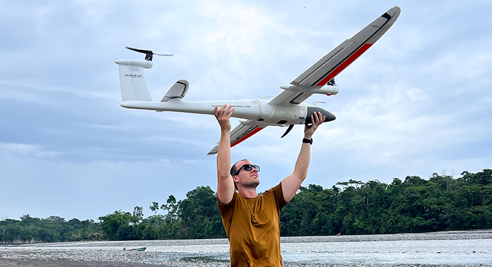
Matt Larson ’15 and his team used drones to map approximately 102 kilometers of the Rio Coca River in Ecaudor.
Drone Technology Tackles Environmental Challenges
When Matt Larson ’15 earned degrees in geology and environmental science and minored in biology, he likely didn’t expect his path would lead to one of the nation’s most prestigious research facilities - or to the rainforests of South America.
Now a researcher at the Department of Energy’s Oak Ridge National Laboratory in Tennessee, Larson uses drone technology to tackle major environmental challenges around the globe. His work recently brought him to Ecuador, where he and his team mapped severe river erosion threatening a hydroelectric dam that supplies nearly 30 percent of the country’s electricity. It’s a career shaped by curiosity, innovation and a willingness to follow where science leads.
Getting into drone technology
Larson originally thought he would pursue a career in the oil industry. Then, during graduate school at Bowling Green State University, a professor introduced him to drones.
“I did my research using a drone and satellites to estimate suspended sediment in a river that flows into Lake Erie,” Larson said. “So that’s really how I got my interest in drone technology.”
After graduating, he found a position in drone remote sensing at Oak Ridge. The job was in the Autonomous Systems Group, working with drones, underwater vehicles, autonomous surface vehicles, ground robots and similar devices under 55 pounds. Many of the projects he works on are tied to the U.S. Department of Defense and military intelligence, which has allowed him to travel extensively.
“Oak Ridge National Laboratory is Department of Energy owned, but contractor managed. So technically, we’re all government contractors,” Larson said.
Role in Ecuador
In 2020, the San Rafael Falls - one of the largest waterfalls in the world - collapsed. One theory suggests the Rio Coca River diverted into a sinkhole, which over time caused the waterfall to erode and disappear.
“We really don’t see this happening anywhere else in the world. Even on a geologic time scale, it is pretty rare,” Larson said.
By 2023, the erosion had started threatening roads, pipelines, homes and the country’s main hydroelectric dam. The river was changing so rapidly that even recent satellite images were outdated by the time they were captured.
“Since you’re in the Amazon, it’s always cloudy. It’s always rainy. You really can’t get imagery from satellite. So, the only way to do it is with drones,” he said.
Larson, his team from Oak Ridge and the National Geospatial-Intelligence Agency were brought in. Their mission was to map approximately 102 kilometers of the river in eight days, analyze three years’ worth of erosion and calculate the current rate of change.
“We provided 3D models of the entire area so that way they can actually calculate how fast it’s eroding,” Larson said. “Their number one concern is how do you reroute roads? How do you prevent it from hitting that dam? Because if that dam goes, that’s a major issue.”
Next steps
The 3D models provided Ecuadorian officials the data needed to predict how much time they have to respond to the erosion. The imagery also supports improved engineering models - scientists can overlay future images and estimate how much sediment has eroded in specific areas.
Larson and his team were expected to do a repeat mission in April to remap the entire 102 kilometers; however, the Ecuadorian government reprioritized funding, canceling the trip.
As for why the waterfall collapsed in the first place, Larson believes a sinkhole next to the falls diverted the river and slowly eroded the area underneath. Once the river changed course, runoff caused the initial collapse.
“We think eventually there’s gonna be a day where it makes it to the dam,” he said. “Hopefully they can prevent it, but as far as the engineering efforts, I’m not 100% sure … because we’re not super involved in that effort.”
Advice to students: Stay curious
Larson says he enjoyed his time back at Oak Ridge headquarters for a few months, but is back on the road again supporting a military exercise integrating technology in Australia.
“It’s not like a private company where all you’re doing is working on this one product for the next 10 years,” he said. “Getting to travel, seeing your work through to the end, having every day be different - that’s my favorite part of the job.”
Asked what advice he would give to his younger self, Larson said:
“I would say try to learn as much as you can. Definitely listen to your advisors. I feel like I could advise a student now, but you know, when we were 18, you thought you knew everything, but you really didn’t.”
“I never had an internship, which I probably wish I would’ve done,” he added. Larson encourages students to check out the paid summer internships offered through Oak Ridge National Laboratory.
His advice for incoming students?
“I know you might have a career in mind, but that’s always going to change. I realized with my geology degree, I thought I wanted to do something and I doubled down and went and got a master’s degree in it. But that wasn’t the end all. I work at a laboratory now, not that I do geology every day, but having the knowledge helps. I can talk more to the science students - it doesn’t really matter what your science degree is in, it’s more on do you want to keep learning something and figure a passion to learn.”
July 10, 2025
© 2025 St. Norbert College | Nondiscrimination Policy | Land Acknowledgement | Privacy Statement | Site Accessibility | Title IX


